
An artist Impression of a Greening the Greyfields development for Maroondah City Council. Source: Your Say Maroondah
Greening the Greyfields: Precinct-scale regeneration in the urban greyfields
Since the late 1980s Australian governments have been trying to curb ever-expanding suburban development (commonly known as urban sprawl), while also accommodating population growth. Contemporary examples of these attempts to reduce car-dependence, and improve neighbourhood liveability and sustainability outcomes include the Melbourne’s city of '20-minute neighbourhoods' and similar projects in Sydney and Adelaide. Despite numerous policy efforts urban sprawl remains an ongoing challenge, with new car-dependent suburbs pushing further and further into the urban fringes each year.
However, since the significant rise of land values in the 1990’s, individuals subdividing their blocks of land for economic gain has become a common business model. This is particularly evident in the middle suburbs of Australian cities, where housing is reaching the end of its lifecycle, where the land represents a majority of the asset value (i.e., the dwelling value is negligible), where land parcels are large enough to accommodate additional dwellings, and where the market has come to accept townhouses and apartments as viable housing typologies. We call these areas ‘greyfields’ as distinct from residential development occurring in ex-industrial sites (brownfields) and in peri-urban areas (greenfields).
To date the outcomes of these suburban subdivisions has been substandard, almost completely occupying the land with concrete/asphalt and reducing tree canopy which increases the negative effects of urban heating and urban flooding. Importantly, such projects also increase population densities without increasing local amenity, which places greater pressure on infrastructures designed for lower density neighbourhoods (including parks, schools, commercially zoned land and community services).

Poor subdivision outcomes
In light of these ongoing challenges, researchers have developed an alternative model of urban redevelopment. Greening the Greyfields is a ten-year project which aimed to develop and implement a new process for housing redevelopment that increased local amenity and density simultaneously. Rather than developing a single lot, and instead incorporating multiple lots in a development, developers and planners can widen the scope of neighbourhood change to look beyond a single site to consider the surrounding neighbourhood precinct, leading to the concept of ‘precinct scale regeneration’.

Idealised precinct scale regeneration: Source, Glackin & Newton, illustration from precinct playbooks
Precinct scale regeneration is a process, where:
- Municipalities create a planning mechanism that allows for greater densities in an area, in return for specific local outcomes that meet the needs of local residents (e.g. reconfigured streetscape, greater tree canopy, underground car parking, flood mitigation, additional parkland etc.).
- Landowners can then voluntarily, and by varied means (timed single sale, joint sale etc.), sell their land to a developer.
- Developers can then obtain development concessions if they concur with the municipal ‘precinct scale’ planning requirements.
As neighbourhoods vary in terms of what they need (more trees, more parks, stormwater relief, more commercial space or services), the planning requirements also need to incorporate the immediate neighbourhood context.
The Greening the Greyfields project identified that overcoming sprawl and more successfully engaging with greyfield regeneration in the established urban fabric of middle-ring suburbs requires a more strategic approach to planning [1]. However, in implementing this new urban redevelopment model, there were a range of barriers to overcome.
Land use change
The primary issue was that of land-use change, as without the legal right to engage in development concessions and obligation there is effectively no legal process, resulting in no benefit to landowners (as their land will not be worth any more if combined), developers (as they will not be able to make more of the land than a typical proposal), or municipalities, who are ultimately aiming to implement new planning policy directives through the scheme (i.e. walkability, tree canopy increase, flood mitigation etc.).
The first step in supporting land use change is developing an evidence base. Figure 2 illustrates the ‘virus’ of small lot redevelopment over a ten year period, in a representative middle suburb in Melbourne. This visualisation demonstrates that, regardless of political, geographical or market context, small lot subdivision in areas zoned Neighbourhood and General Residential is occurring on a reasonably large scale. It also shows that at some point in the future, the majority of land parcels will be subdivided (typically into 200m2 lots), and once subdivided it will prove very difficult (if not impossible) and expensive to re-assemble. As such we will see ongoing fragmentation of land ownership going forward.
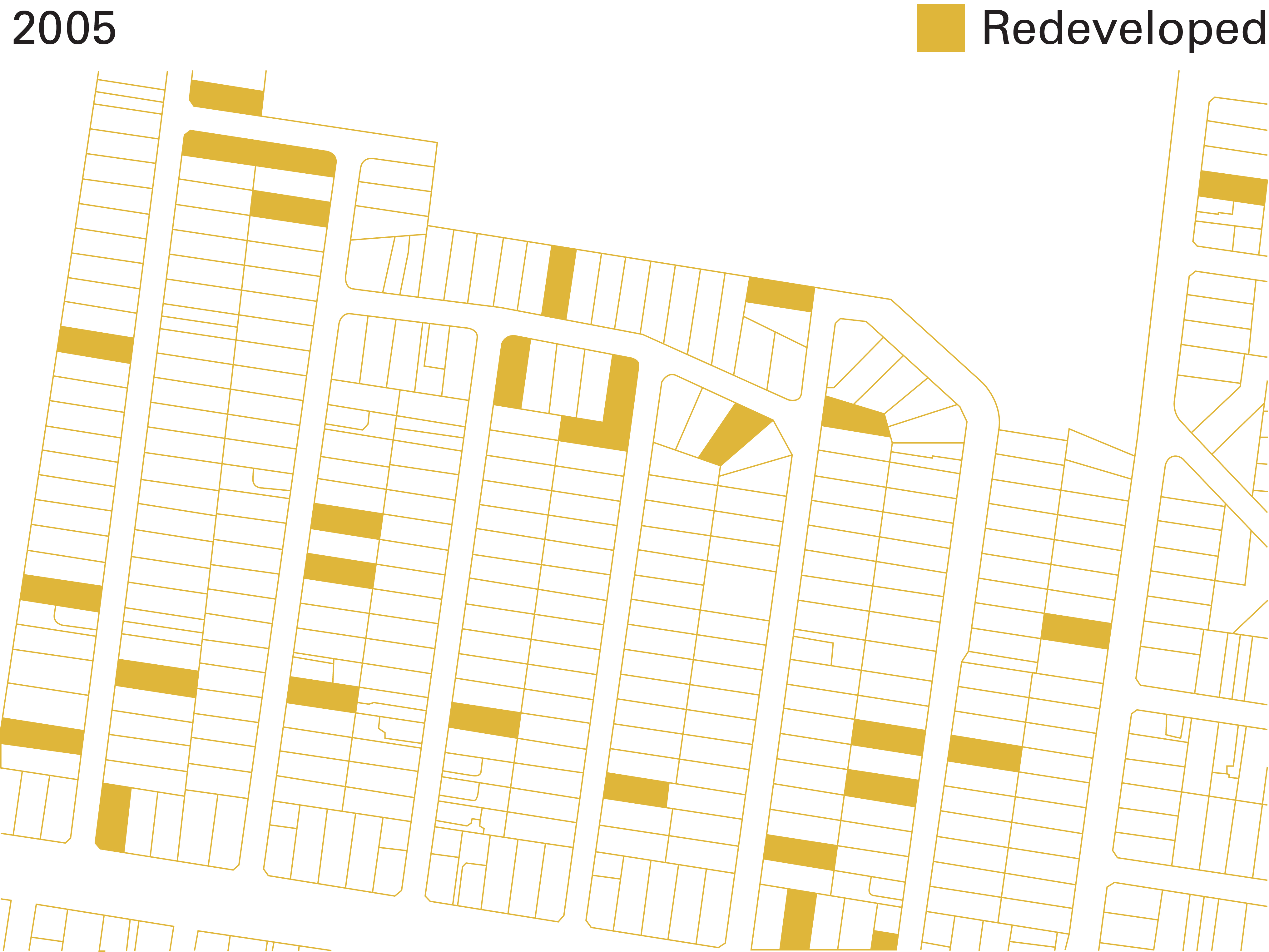
Figure 2: Housing redeveloped 2005-2016

Figure 3: High redevelopment land parcels and redeveloped parcels as of 2016
There is however, unrecognised potential for joint redevelopment in abutting land parcels, especially when we view the remaining high-redevelopment potential (Figure 3). This, particularly when we consider the limited designs of single lot redevelopment, serves as the key rationale for change - the identification of a problem but also an opportunity to act otherwise.
The second step in supporting land-use change is to begin to identify the locational opportunities and desired outcomes of both the local community and Council. This involves significant levels of collaborative design with both groups involving discussions around benefits to the community, housing types, financing, and the design of the precincts. This is the most onerous part of the process as it requires deep commitment to community engagement and co-design processes across multiple disciplines, most of which are not part of a Council’s typical responsibilities or capabilities.
Beyond these steps, the process also involves passing through the heavily regulated process of formal land-use change, and establishing the business logic of how municipalities, developers and landowners can work together to implement these process across jurisdictions and achieve the desired outcomes (See the Greening the Greyfields playbooks linked below for further detail).
As municipalities control planning schemes, the opportunity to change the future of our cities primarily lies with them. However, most are already under-resourced and struggling to perform their business-as-usual activities, let alone drive innovative planning processes such those coming from state planning authorities. As such, and evidenced by the outcomes of this project, there is space for project collaboration to map the implementation pathways for these aspirational projects. Similarly, there is a need for established business models and joint implementation procedures if we are to see any significant urban transformation at scale.
The Greening the Greyfields model has successfully moved from concept to implementation. Though the concept was developed by Professor Peter Newton, the shift to implementation required a collaborative partnership between municipal, state and federal partners, and researchers working across housing and development, planning, typology development, financial feasibility, community engagement and co-design processes.

A visualisation of a Greening the Greyfields pilot precinct in Maroondah, Melbourne
Greening the Greyfields is now a municipally led program of precinct scale regeneration in the middle suburbs, endorsed by the Victorian Planning Panel. Work is ongoing to develop new precincts, expanding to new municipalities and to develop the business case to mainstream the process to developers.
A blueprint for a better future has been created, but it took ten years and multiple competitive research and industry grants, financial support from state government, as well as a significant commitment from Maroondah City Council, our partner municipality. This is illustrative of the cost and effort required to deliver the type of innovative (i.e., not business as usual) solutions required to create more resilient, equitable and sustainable neighbourhoods.
As key institutions delivering the future of our cities it is municipalities, in collaboration with universities, that need additional support and funding to enable them to achieve the outcomes set out in global, federal and state policies for sustainable urban development.
Greening the Greyfields book:

Greening the Greyfields playbooks:


Acknowledgements
The authors would like to thank the CRC for Spatial Information, the CRC for Low Carbon Living, The Federal Smart Cities and Suburbs Program, the Victorian Planning Authority, the Victorian Department of Environment, Land, Water and Planning, and especially the staff at Maroondah City Council. We also wish to acknowledge the Victorian Planning Institute of Australia (PIA) and their 2021 President’s Award for Greening the Greyfields.
—
Stephen Glackin
Stephen is a senior research fellow at Swinburne University’s Centre for Urban Transitions in Melbourne, Australia. He is currently engaged in the various disciplines related to urban regeneration; including geo-spatial analysis, urban planning, statutory regimes, community engagement, financial feasibility analysis, urban design and the new business models needed to drive co-development.
Peter Newton
Peter Newton is a Research Professor in the area of sustainable built environments at Swinburne’s Centre for Urban Transitions. His research focus is on sustainable urban development, socio-technical innovation and urban transition studies, sustainable consumption and low carbon living, green economy transition, urban experimentation and performance assessment (via iHUB national network), and greyfield precinct regeneration.
Cities People Love (est. 2020) is a social enterprise organisation dedicated to the creation and curation of urban research that can engage and empower communities to influence policy and practice.
Similar Stories

Cities People Love is licensed under a Creative Commons Attribution 4.0 International License.